From Civil Defense to FEMA – A History of Emergency Response

Civil Defense and Homeland Security: A Short History of National Preparedness Efforts (2006)

This report is the result of a requirement by the Director of the Department of Homeland Security’s National Preparedness Task Force to examine the history of national preparedness efforts in the United States. The report provides a concise and accessible historical overview of U.S. national preparedness efforts since World War I, identifying and analyzing key policy efforts, drivers of change, and lessons learned. While the report provides much critical information, it is not meant to be a substitute for more comprehensive historical and analytical treatments. It is hoped that the report will be an informative and useful resource for policymakers, those individuals interested in the history of what is today known as homeland security, and homeland security stakeholders responsible for the development and implementation of effective national preparedness policies and programs.

The Federal Emergency Management Agency (2010)

Publication 1 (Pub 1) is the Federal Emergency Management Agency’s (FEMA’s) capstone doctrine. Pub 1 describes FEMA’s ethos, which is to serve the Nation by helping its people and first responders, especially when they are most in need. It identifies FEMA’s core values of compassion, fairness, integrity, and respect. Finally, Pub 1 delineates eight guiding principles that provide overarching direction to FEMA employees for the performance of their duties.

Introduction to Crisis, Disaster, and Risk Management Concepts

The purpose of this chapter is to introduce the reader to current and historical crisis, disaster and risk management concepts, to define the four phases of emergency management, and to highlight issues concerning communications, business continuity planning and international disaster programs.  Also included in this chapter is a discussion of the attributes of a successful emergency management system that will be illustrated in the case studies presented in this book.
 

The Origin Story for Horizontal Levees

A fundamental premise of the most Louisiana coastal restoration plans, including the Master Plan, is that coastal salt marsh acts as a horizontal levee, reducing hurricane surge for each mile of marsh. The primary source that is usually cited for this proposition is:

Corps of Engineers, US Army Engineer District, New Orleans, Interim Survey Report, Morgan City, Louisiana and Vicinity , serial no. 63, US Army Engineer District, New Orleans, LA (November 1963).

This report is nearly impossible to find because it is embedded in a transmittal document with a different citation.

Why the Master Plan will not protect Louisiana and what we should do instead

Coastal Louisiana is disappearing into the Gulf of Mexico. While the media focuses on the loss of land, polls of residents indicate that the real concern is the flood risk to the communities, farms, and businesses in southern Louisiana. The Louisiana Coastal Preservation and Restoration Authority has just rolled out the 2017 Coastal Master Plan. The Master Plan proposes using dredging and river diversions to build on the edges of the coast in areas of open water. The goal is to reduce the flood risk by slowing the overall loss of land. Many scientists question whether this land can be built, how long it will last, and the financial and environmental costs of trying to build it. It is not necessary to resolve these scientific controversies because slowing the overall loss of land will not protect communities, farms, and businesses from hurricane surge and the day to day flooding driven by sea level rise and subsidence.

The estimated cost of the Master Plan range from $50-100 billion or more, over a 50 year time period. Recognizing the scientific uncertainty about the proposed projects, the proponents of the Master Plan argue that it is better to do something than nothing, that we are no worse off if the projects do not work. But time and money are limited. The tens of billions of dollars that are proposed for Master Plan projects would be better spent on other projects that would provide real and immediate protection, such as maintaining existing levees. This would make coastal communities safer and buy time for longer term strategies to migrate away from the coast.

Reflecting upon 10 Years of Geoengineering Research

http://agupubs.onlinelibrary.wiley.com/hub/issue/10.1002/(ISSN)2328-4277.GEOENGIN1/

Reflecting upon 10 Years of Geoengineering Research: Introduction to the Crutzen + 10 Special Issue

“Ten years ago, Nobel laureate Paul Crutzen called for research into the possibility of reflecting sunlight away from Earth by injecting sulfur particles into the stratosphere. Across academic disciplines, Crutzen’s intervention caused a surge in interest in and research on proposals for what is often referred to as “geoengineering” – an unbounded set of heterogeneous proposals for intentionally intervening into the climate system to reduce the risks of climate change. To mark the 10 year anniversary of the publication of Paul Crutzen’s seminal essay, this special issue reviews the developments in geoengineering research since Crutzen’s intervention and reflects upon possible future directions that geoengineering research may take.”

A great collect of open access articles on Geoengineering

Implications for US National Security of Anticipated Climate Change

Implications for US National Security of Anticipated Climate Change (2016)

Key Points

Long-term changes in climate will produce more extreme weather events and put greater stress on critical Earth systems like oceans, freshwater, and biodiversity. These in turn will almost certainly have significant effects, both direct and indirect, across social, economic, political, and security realms during the next 20 years. These effects will be all the more pronounced as people continue to concentrate in climate-vulnerable locations, such as coastal areas, water-stressed regions, and ever-growing cities.

Science and the Storms: the USGS Response to the Hurricanes of 2005

Original link

USGS - science for a changing world
 Circular 1306:  Science and the Storms: the USGS Response to the Hurricanes of 2005

Thumbnail of and link to Front Cover PDF (1.15 MB)Download Publication

Preface

This report is designed to give a view of the immediate response of the U.S. Geological Survey (USGS) to four major hurricanes of 2005: Dennis, Katrina, Rita, and Wilma. Some of this response took place days after the hurricanes; other responses included fieldwork and analysis through the spring.

Arctic Report Card: Update for 2016

J. Richter-Menge, J. E. Overland, and J. T. Mathis, Eds., 2016: Arctic Report Card 2016, http://www.arctic.noaa.gov/Report-Card.

Highlights

  • The average surface air temperature for the year ending September 2016 is by far the highest since 1900, and new monthly record highs were recorded for January, February, October and November 2016.
  • After only modest changes from 2013-2015, minimum sea ice extent at the end of summer 2016 tied with 2007 for the second lowest in the satellite record, which started in 1979.
  • Spring snow cover extent in the North American Arctic was the lowest in the satellite record, which started in 1967.
  • In 37 years of Greenland ice sheet observations, only one year had earlier onset of spring melting than 2016.
  • The Arctic Ocean is especially prone to ocean acidification, due to water temperatures that are colder than those further south.  The short Arctic food chain leaves Arctic marine ecosystems vulnerable to ocean acidification events.
  • Thawing permafrost releases carbon into the atmosphere, whereas greening tundra absorbs atmospheric carbon.  Overall, tundra is presently releasing net carbon into the atmosphere.
  • Small Arctic mammals, such as shrews, and their parasites, serve as indicators for present and historical environmental variability. Newly acquired parasites indicate northward sifts of sub-Arctic species and increases in Arctic biodiversity.


Underwater – A Report on the Threat of Sea Level Rise in the New York City Metro Area

Under Water How Sea Level Rise Threatens the Tri-State Region, A Report of The Fourth Regional Plan, December 2016.

Coastal regions around the world are struggling to adjust to the gradual but relentless encroachment of ocean waters caused by climate change. The New York metropolitan area, with 23 million residents and some 3,700 miles of tidal coastline, faces a severe threat from sea level rise, yet relatively little has been done to address the inevitable permanent inundation of buildings, infrastructure and communities.

Permanent flooding from sea level rise is different than the intermittent flooding from storm surge or precipitation. Intermittent flooding recedes once a storm passes while sea level rise flooding is permanent and can be expected to encroach further inland over time. Sea level rise not only permanently alters the coast line. It also widens the area vulnerable to storm surge.

This report identifies the places in the New York, New Jersey and Connecticut metropolitan area that are most at risk of being permanently flooded, and describes the effects of 1, 3 and 6 feet of sea-level rise on neighborhoods, employment centers and infrastructure. Taking into account the latest scientific findings on sea level rise and climate change, the study finds that many of the major resilience policies, plans and projects under development today fall short of adequately addressing the long term, existential threat of permanent flooding from sea level rise.

Louisiana Coastal Land Loss Since 1956

land-loss-since-1956-small

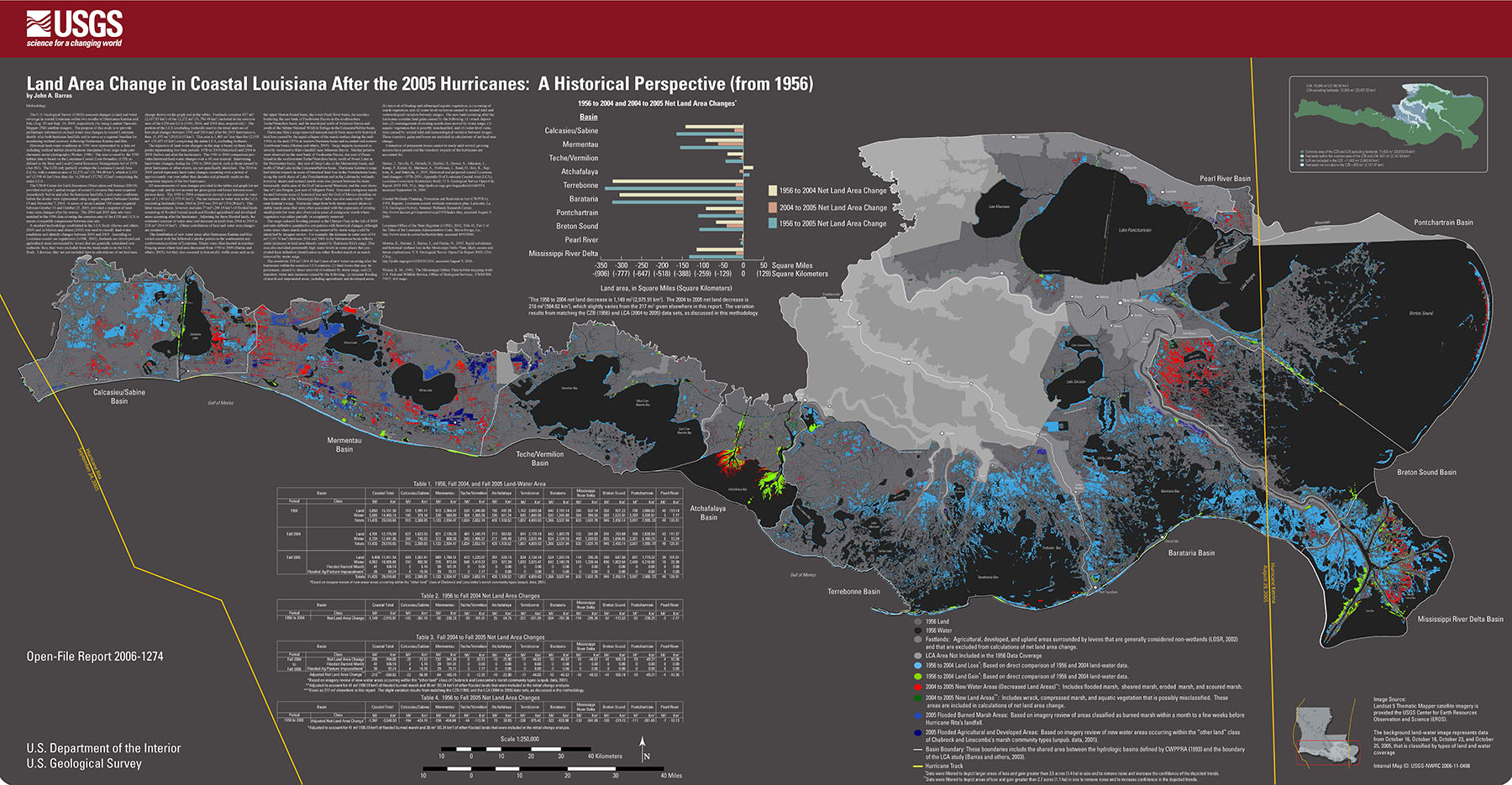
Land Area Change in Coastal Louisiana After the 2005 Hurricanes: A Historical Perspective (from 1956) – Full Size Poster

This map only shows land as lost when it is turned to open water. There are large areas of land, such as the area east of New Orleans, that have lost most of their elevation since 1956, but are still just barely above water. They will disappear from the map as go below water, creating the impression of sudden land loss when the reality is that a long term process of subsidence. If you fly over the area or try to walk on this land, it is clear that it is already lost and is just awaiting the final death of the marsh to disappear into open water.

EPA Rejects Corps EIS for Columbia River Coal Terminal

millennium-bulk-terminals-nepa-eis

The U.S. Environmental Protection Agency has reviewed the U.S. Army Corps of Engineers’ September 2016 Millennium Bulk Terminals – Longview Draft Environmental Impact Statement (Corps DEIS), (EPA Region 10 Project Number: 13-0034-COE). We conducted our review according to EPA’s responsibilities under the National Environmental Policy Act (NEPA) and Section 309 of the Clean Air Act. Section 309 specifically directs the EPA to review and comment in writing on the enviromnental impacts associated with all major federal actions. Our review of the Corps DEIS considers the expected enviromnental impacts of the proposed action and whether the EIS meets the procedural and public disclosure purposes of NEPA. For the reasons described below, we are rating the Corps DEIS “3” – Inadequate.

Mississippi Delta Subsidence in Action – Fort Proctor

Photo by Marli Miller – marlimillerphoto.com

A visualization of century-scale impacts of subsidence and sea level rise as seen in a time sequence reconstruction at Fort Proctor in St. Bernard Parish, Louisiana

by Chris McLindon

Fort Proctor is a pre-civil war military installation on the shore of Lake Borgne southeast of New Orleans. Historical records state that the fort was constructed 150 feet inland from the shore of the lake just north of the mouth of Bayou Yscloskey. This was also the site of Proctorville, a rail depot at the terminus of the Shell Beach Branch of the New Orleans and Gulf Railroad, which ran along the east bank of the Mississippi River to the town of Poydras, then down the natural levees of Bayou Terre aux Boeufs, Bayou La Loutre and Bayou Yscloskey to the shore of Lake Borgne.

While it can logically be assumed that the original elevations of the fort and the railroad depot were necessarily at least a few feet above sea level, neither of the architectural studies of the fort conducted by Tulane or Louisiana State Universities appear to include any definitive values for the land elevation at the time of construction. The fort is about 1,000 feet from the Shell Beach Continuously Operating Reference Station (CORS) of the National Geodetic Survey. This station is a part of the Global Navigational Satellite System that provides data for the three-dimensional Global Positioning System (GPS) network. In addition to surface positioning data this station provides a measurement of the vertical movement of the earth’s surface, which in this case can be used to estimate a rate of subsidence.